


金沢大学人間社会研究域地域創造学系の青木賢人准教授は、広島大学、千葉県立中央博物館、福岡教育大学、兵庫教育大学、山口大学、岡山大学、金沢大学から成る研究チームのメンバーとして、令和6年能登半島地震に伴って発生した海岸の隆起量の精密な計測を実施するとともに、海底地形データ等から沿岸近傍に分布する海底活断層の位置と形状を明らかにしました。特に青木賢人准教授は、発災直後から実施してきた現地調査の情報を提供し、研究チームの現地調査の円滑な実施を図るとともに、チームの一員として調査にあたりました。
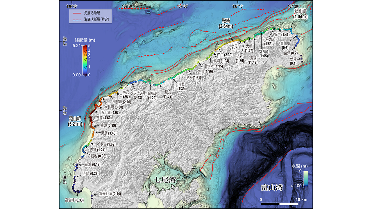
調査の結果、令和6年能登半島地震に伴う隆起域の延長は約100キロメートルに及び、世界最長級であることが明らかになりました。海岸線に沿って510地点で隆起量を計測した結果、隆起量は0.1〜5.2メートルで、大きな隆起は北西端の猿山岬付近および北岸の鞍崎周辺で観測されました。
一方、海底地形データや地層探査データの解析から、隆起をもたらした活断層が海岸線にほぼ平行して連続的に延びていることが明らかとなりました。隆起量が特に大きかった場所は断層線に近接する陸域に集中しており、南に傾斜した逆断層の活動によって隆起量分布が説明できることが確認されました。
従来、海岸線に極めて近い海底活断層は調査が難しく、十分に注目されていませんでした。本研究では、海底地形データの解析と陸上での地形調査を組み合わせることで、これらの断層の動きを初めて明瞭に捉えることに成功しました。
本研究成果は、国際的学術誌『Geomorphology』に掲載されました。
図:2024年地震の隆起量と海底活断層の分布
【用語解説】
・海岸隆起
地震によって地盤が持ち上がる現象。海岸では、地震前に海水面の影響でできた痕跡(波の跡や海藻の付着跡など)が、地震後に海面より高い位置に現れることで、隆起の様子を確認できる。不動とみなせる海水面を基準に、これらの痕跡との高さの差を比べることで、地震による隆起量を知ることができる。
・海底活断層
海底にあり、過去に何度も動き、将来も活動すると考えられる断層。沿岸の近くに分布する場合、断層面が陸地の下まで延びていることもあり、地震のときには津波だけでなく強い揺れをもたらすことがある。
ジャーナル名:Geomorphology
研究者情報:青木 賢人
関連情報
金沢大学 人間社会学域 地域創造学類:https://chisou.w3.kanazawa-u.ac.jp/
金沢大学大学院 自然科学研究科:https://www.nst.kanazawa-u.ac.jp/